Every year it is the responsibility of Yolo Land Trust (YLT) to properly steward the lands that are held in conservation easements.
To best do this, YLT visits each conservation easement to monitor the farming activity on the property to confirm that the tenets of the Conservation Easement Agreement are being upheld. The core purpose of YLT’s agricultural conservation easements are to enable the Conservation Easement to remain in agricultural use by preserving and protecting its soils, agricultural productive capacity, agricultural viability, utility, character, and values.
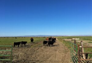
Of the 75 conservation easements in YLT’s conserved lands portfolio, all but one is established as an agricultural conservation easement. YLT holds one 7-acre non-farming habitat conservation easement that provides a natural, open space buffer between developed land and agricultural land in easement. The other 74 agricultural easements represent a diverse collection of working lands dedicated to row crops, orchards, vineyards, and pasturelands.
According to Liz Heckles, Land Stewardship Director of Yolo Land Trust, monitoring allows YLT to ensure the public benefit of preserving prime farmland is being upheld. “Monitoring allows us to visit each farm every year to meet with the landowner and to confirm the agricultural use of the land continues. Plus, I can answer any questions that arise regarding the terms of the easement.” The activity of monitoring is a collaborative process between the landowner and the easement holder (YLT).
Heckles is responsible for visiting all of Yolo Land Trust’s conservation easement farms annually. She began monitoring on March 30 and finished her last easement visit on October 12. As YLT acquires more farms in their conservation portfolio the time it takes to complete monitoring is lengthened.
“This year I’ve spent about 30 weeks focused heavily on conservation easement monitoring, and have traveled nearly 2,000 miles for YLT-related conservation, outreach and stewardship. Over 1,400 of these miles were logged travelling from Clarksburg to Capay, West Sacramento to Winters, and points in between, in order to conduct monitoring visits on the nearly 13,000 acres of farmland under conservation in YLT’s easement portfolio,” Heckles explains.
The observations of each yearly site visit are recorded in a monitoring report prepared by Heckles shortly after her survey of each easement farm. At the time YLT closes on a conservation easement a baseline report is prepared to document the current conditions of the farm. Each subsequent year after the conservation easement was established, a monitoring report is prepared to demonstrate that the terms of the conservation easement are maintained. And although crops may change and farming practices may evolve, the commitment to preventing development is documented through the annual monitoring report. These valuable reports serve many purposes and are shared with federal and state funding agencies, local agencies, and the landowner.
Interested in learning even more about YLT’s monitoring efforts in 2022? Recently, Heckles answered questions about her monitoring efforts. She even shares insight into general observations she saw across our conservation easements demonstrating the ever changing qualities of agriculture as farmers make improvements on their farms to be more efficient and respond to changes in the commodities market.
When did you start and finish monitoring this year?
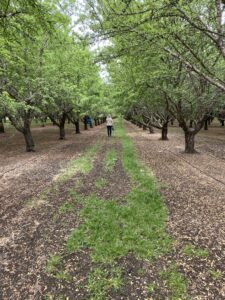
I began YLT’s annual monitoring season on the last week in March with two of our conservation funded easements that are situated in the “Davis-Woodland Greenbelt”. One of these properties is an almond orchard so I always try to schedule my visit to avoid impacting almond bloom.
My last monitoring site visit was completed on October 12, 2022. At this point in the season, it’s great to visit row crop farmers who plant late harvest crops like pumpkins and squash.
How do you determine what order you will visit farms and when?
Some of the easement farms I visit have reporting requirements with a time-sensitive deadline, so those farms and orchards are usually scheduled with priority. If there are important changes happening on an easement property, perhaps a new owner, a transition to a different crop or construction of a permitted building I take that into account when scheduling. I also consider the crops grown on each easement and try to plan to visit near the peak of growing cycle so I can really get a good idea of how the land is being used while also being mindful not to impact critical activities for growers such as harvest, spray cycles or pollination periods. With properties that have permanent crops I am trying to vary my monitoring visits from year to year so I can catch the range of cultural practices and crop developments that happen from early spring, to mid-summer and late summer.
Does anyone accompany you when monitoring?
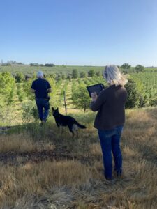
I am often joined by landowners, ag managers, tenants or local liaisons when conducting a monitoring site visit. This year I met with 28 landowners or representatives on site during monitoring visits. Many times I survey a farm or property by myself, but it is especially helpful to hear about agricultural improvements, farming practices, resource use, cropping plans, farming leases, or ag-related incentive projects that may have happened in the past year or are planned for the future when I am on-site with a landowner or farming representative.
What supplies do you need to complete monitoring?
A decent camera and GPS are the most important tools. YLT is currently using an iPad and photo/mapping software to document each easement year after year to demonstrate and document compliance with the terms of each conservation easement. Some land trusts have moved to using drones to monitor remotely, but most farm ground in Yolo County is very easy to access and assess in-person.
What do you do with the information collected on monitoring visits?
Information collected during annual monitoring visits is used:
- To determine that the terms of each easement are continually maintained.
- To demonstrate to federal and state funding agencies that the grants they’ve made to landowners have been used appropriately.
- To assist other local agencies involved in conservation or agricultural issues in tracking trends regarding land use in Yolo County.
- In the extremely rare case of an easement violation the information collected during monitoring visits can be used in litigation or dispute resolution.
Do you have any general observation of things you saw during this year’s monitoring visits?
This year we’ve acquired 4 new conservation easements since November 15, and may add one more to close out this year. I’ll be adding these farms to my monitoring itinerary in 2023, which means I’ll be visiting 80 easements across Yolo County.
Fortunately we haven’t seen any violations or specific challenges in 2022, but landowners have been busy as farming continues to evolve locally. Two properties that have been under conservation easement for 20 years have been transferred or are in escrow to transfer to new owners, three farms have successfully petitioned for or completed construction on ag-related buildings in accordance with the easement terms, and one easement property is involved in an eminent domain issue on a portion of the conservation land.
Following local trends in crop diversity, there have been some crop changes on our easement farms, with some orchards being removed and other farming operations converting from row crops to orchards.